The Waag Valley is situated SSW of Hieflau, N of Lugauer Peak (2211 m). Placed at the N rim of the Mürz Alps Nappe (Juvavicum), it consists mainly of Dachstein Limestone (Upper Triassic) and Lower Jurassic limestones. At the S slope, there are glacial gravels at relatively high elevations above the Erzbach Valley (50-170 m). Further upstream, there is a small occurrence of the Gosau Formation (Upper Cretaceous), which is very interesting nevertheless. At a roadcut, you can see a 10-m-high rudist reef. The rocks consist solely of the fossil bivalves Hippurites and Gryphaea (?) and the snail Actaeonella.
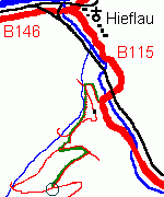
 Access: On the road to Eisenerz (B 115), leave Hieflau, pass through under the railway, cross
the Erz River and immediately turn right (follow the Sportplatz sign). Drive uphill, bend to the left
and park your car where a small road turns left.
Always follow the red marks (leading to
Goldeck and Lugauer Peak), on that road at first, but soon turning right on a narrow path
(you can see the gravels of the glacial terrace here). After few minutes, you reach a road again, where
you turn right. Pass a crossing, bend to the left (hairpin bend) and leave the road again, using a marked footpath to
the right. After another quarter of an hour, you will reach the road that cuts the
Hippurite reef - here you are!
Walk: good half of an hour, difference in altitude: 230 m, walking shoes recommended!
Austrian Coordinates (BMN): easting=555800, northing=273150, altitude 770 m
Google Maps
Visited by the author: Aug 27, 1998
The town Eisenerz ("Iron Ore") is situated at the transgressive contact of the Greywacke Zone (Lower Palaeozoic slates, greywackes and limestones that were folded during the Variscian Orogeny) and the Northern Calcareous Alps (post-variscian Permian to Cretaceous sediments). Near the Leobner Hut at the Polster Peak (ESE Eisenerz, N Vordernberg), you can see the contact particularly well. The underlying rocks are comprised by the low-stage metamorphic Devonian Polster Limestone, which is covered unconformably by the Permian Präbichl Formation, a base conglomerate built of fist-sized Polster Limestone rubble in a red matrix. The unconformity plane dips vertically, striking W - E, and can be viewed best W of the Leobner Hut - the conglomerate faces N of the underlying limestones above the Knappensteig ("miner's track") look quite peculiar when viewed from the distance. See also Univ. of Salzburg.
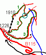
 Access from Präbichl Pass (B 115, altitude 1226 m).
Way #1: Take the chairlift to Polster Peak (altitude 1910 m), descend along the NE ridge
until you reach the Hirschegg Saddle (Werfen Slates and Breccias) and turn S to get to the Leobner Hut (good half of an hour's walk, marked).
Way #2: Take the Knappensteig ("miner's track") at Polster's S slope, from Präbichl Pass directly to the hut
(good hour's way, difference in altitude: 380 m, steep at the beginning, marked).
Way #3: From Präbichl Pass, take the Laufstraße to ESE and ascend to the hut through
Handl Valley in a long bend (one and a half hours, difference in altitude 350 m, rather flat, marked).
Right behind Leobner Hut, conglomerate rock can be found, but the best exposure lies further to the W
(three minutes heading to Präbichl Pass on the Knappensteig).
Walking shoes recommended!
Coordinates (BMN): easting=647800, northing=266900, altitude=1590 m to 1610 m
Google Maps
Visited by the author: Aug 26, 1998
To be continued!
 Back to Christof Kuhn's Homepage
Responsible for the content:
Christof Kuhn office@geol-info.at
Last modified: Sept 9, 2009